Active Kilitop and Safaris

'
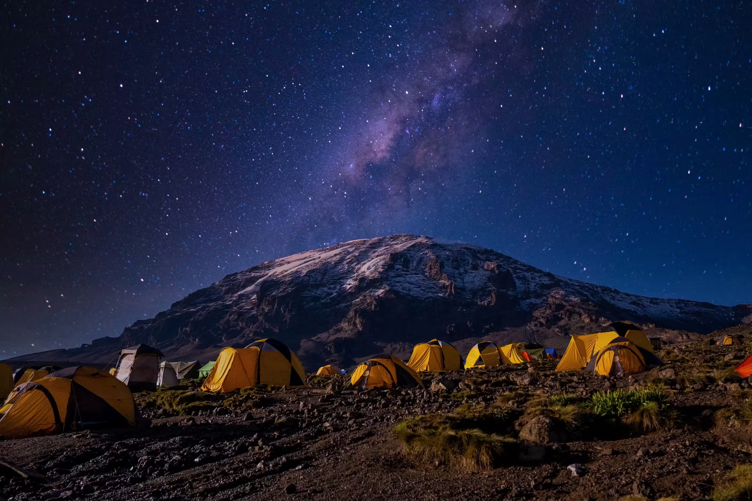
Tents under the night sky below Kilimanjaro
Home/Kilimanjaro/Northern Circuit Route
Kilimanjaro · 9 days · Western start, northern slopes · Private climb

Northern Circuit Route

Nine days in from the western forest and round the empty northern side of the mountain — the longest route on Kilimanjaro, the quietest, and the one that gives the body the most time to adjust.

Londorossi GateShira PlateauMoir HutSchool HutUhuru PeakMweka Gate
Length9 days · 8 nights on the mountain
SummitUhuru Peak, about 5,895 m
Starts & endsLondorossi Gate / Mweka Gate
SleepingTents, eight camps
Best monthsJanuary–February, June–October
IOverview

The long way round, and the quiet one.

The Northern Circuit starts like Lemosho, on the quiet western side, and crosses the Shira Plateau. Where Lemosho turns south for Barranco, this route turns north: past Lava Tower to Moir Hut and then all the way round the northern slopes of Kibo, where you will see very few other climbers, before the summit from School Hut on the eastern side.

It is the longest route on the mountain and gives the body the most time at moderate altitude before the summit. What it asks in return is nine days on the mountain, the cost of those extra days, and a very long summit day: up from School Hut and all the way down to Mweka Camp. If the days or the budget will not stretch, Lemosho gives you most of the quiet in eight.

Major attractions · 4
  1. 01Kilimanjaro National Park
  2. 02Shira Plateau
  3. 03Kibo’s northern slopes
  4. 04Uhuru Peak
Trip detailsPrivate climb
Length
9 days · 8 nights on the mountain
Route
Lemosho start, round the northern slopes
Start / end
Londorossi Gate (west) / Mweka Gate (south)
Sleeping
Tents, eight camps
Summit
Uhuru Peak, about 5,895 m
Group size
Maximum per private climb
Meals
Three meals a day on the mountain
Best period
Jan–Feb · Jun–Oct
Fitness
No technical climbing — many days walking at altitude, one very long
Request a free quote →Questions? WhatsApp +255 762 914 714
IIThe route

In from the west, round the north, down the south.

9 days, 8 nights, 8 places to sleep. The solid line is this plan; the dotted lines are the other roads through the region. Point at a day to see its leg.

Route map: The Northern Circuit: Londorossi and Lemosho Gates, the Shira Plateau, Lava Tower, Moir Hut, Pofu, Third Cave, School Hut, Uhuru Peak and down to Mweka Gate Kilimanjaro NP Kibo N Uhuru Peak Mti Mkubwa Shira 1 Shira 2 Mweka Camp Moir Hut Pofu Third Cave School Hut Londorossi Gate Mweka Gate Lemosho Gate Lava Tower
Drawn to scale

Every metre up, and every metre down.

Three nights rising slowly across the Shira Plateau, then up to Lava Tower at about 4,630 m and down to sleep at Moir Hut, about 4,200 m. The days round the north stay close to 4,000 m, which is where the extra acclimatisation comes from — but the summit push starts from School Hut, about 4,800 m, and the day that follows is very long.

Elevation profile: Northern Circuit Route 2,000 3,000 4,000 5,000 6,000 Day 1 Day 2 Day 3 Day 4 Day 5 Day 6 Day 7 Day 8 Day 9 Lemosho Gate Mti Mkubwa Shira 1 Shira 2 Lava Tower Moir Hut Pofu Camp Third Cave School Hut Uhuru Peak Mweka Camp Mweka Gate Metres above sea level. Altitudes rounded; published figures for some camps differ by up to about 100 m.
IIIDay by day

Nine days, one at a time.

Each day lands on top of the last as you scroll: honest road time, game time, meals and where you sleep. Times are door to door in a safari vehicle and move with the season and what you stop for.

Moss-hung montane forest on the Lemosho trail, a line of porters on the path — 1600×1200
Mti MkubwaADD IMAGE · Moss-hung montane forest on the Lemosho trail, a line of porters on the path
01/ 09

About 3–4 hours by road round the mountain, registration, then a short first walk into the forest.

03°00′S 37°11′EDay 1 · Moshi → Londorossi Gate → Lemosho Gate → Mti Mkubwa

Round the mountain to the western forest

Travel
~3 h walking + ~4 h road
Highest point
Mti Mkubwa, about 2,890 m
Meals
L · D
Sleep
Tented camp, about 2,890 m
  1. Morning

    Collected from your hotel in Moshi and driven round the western side of the mountain to Londorossi Gate, about 2,250 m, for registration and the weighing of the porters’ loads.

  2. Afternoon

    On to Lemosho Gate, about 2,100 m, and a gentle first walk through montane forest. Afternoon rain is common.

  3. Evening

    Mti Mkubwa at about 2,890 m. The guide’s first evening check, and a briefing on the nine days ahead.

Pole pole

Slowly, slowly. The pace will feel too easy. It is meant to.

Heather and giant heath on the western rim of the Shira Plateau, Kibo on the horizon — 1600×1200
Shira 1ADD IMAGE · Heather and giant heath on the western rim of the Shira Plateau, Kibo on the horizon
02/ 09

About 5–6 hours, forest giving way to heath and moorland.

03°01′S 37°14′EDay 2 · Mti Mkubwa → Shira 1

Out of the trees onto the Shira Plateau

Travel
~6 h walking
Highest point
Shira 1, about 3,500 m
Meals
B · L · D
Sleep
Tented camp, about 3,500 m
  1. Morning

    The forest thins into giant heath and the path climbs onto the rim of the Shira Plateau, an old collapsed caldera.

  2. Afternoon

    Across the moorland to Shira 1 at about 3,500 m, with the first full view of Kibo if the cloud allows.

  3. Evening

    Many people notice the height for the first time tonight. Tell the guide at the evening check.

The open moorland of the Shira Plateau at midday, the path running east towards Kibo — 1600×1200
Shira 2ADD IMAGE · The open moorland of the Shira Plateau at midday, the path running east towards Kibo
03/ 09

A short day, about 4 hours, gaining only a few hundred metres.

03°03′S 37°17′EDay 3 · Shira 1 → Shira 2

Across the plateau

Travel
~4 h walking
Highest point
Shira 2, about 3,850 m
Meals
B · L · D
Sleep
Tented camp, about 3,850 m
  1. Morning

    An easy walk east across the plateau, Mount Meru to the west on a clear day.

  2. Afternoon

    Into Shira 2 at about 3,850 m in good time, with perhaps a short walk higher and back before dinner.

  3. Evening

    Rest is part of the plan. Drink, eat, sleep.

Tents in the sheltered valley at Moir Hut below the lava walls of Kibo’s western side — 1600×1200
Moir HutADD IMAGE · Tents in the sheltered valley at Moir Hut below the lava walls of Kibo’s western side
04/ 09

About 6–7 hours. Up to about 4,630 m, then down to sleep at about 4,200 m.

03°03′S 37°18′EDay 4 · Shira 2 → Lava Tower → Moir Hut

Lava Tower, then north to Moir

Travel
~7 h walking
Highest point
Lava Tower, about 4,630 m
Meals
B · L · D
Sleep
Tented camp, about 4,200 m
  1. Morning

    East into alpine desert and up to Lava Tower at about 4,630 m — the highest you will have been.

  2. Midday

    Lunch near the tower. Headache and breathlessness here are common and expected.

  3. Afternoon

    Where the southern routes turn right for Barranco, you turn north, down to Moir Hut at about 4,200 m in a quiet valley. From here on you will see few other climbers.

Climb high, sleep low

A few hours at about 4,630 m, then a night about 430 m lower. It is the same idea as Lemosho’s Lava Tower day, with a higher camp at the end of it.

A faint path across the dry, open northern slopes of Kilimanjaro, the plains of Kenya far below — 1600×1200
Pofu CampADD IMAGE · A faint path across the dry, open northern slopes of Kilimanjaro, the plains of Kenya far below
05/ 09

About 6–7 hours traversing the empty northern side of Kibo.

03°01′S 37°22′EDay 5 · Moir Hut → Pofu Camp

Round the northern slopes

Travel
~6½ h walking
Highest point
Moir Hut, about 4,200 m
Meals
B · L · D
Sleep
Tented camp, roughly 4,000 m (approximate)
  1. Morning

    A climb out of the Moir valley, then a long traverse east across the northern slopes, up and down over ridges.

  2. Afternoon

    On round the mountain to Pofu Camp. Its height is not formally recorded; roughly 4,000 m is the usual figure.

  3. Evening

    Some of the quietest camps on the mountain. On a clear evening the plains of Kenya stretch out to the north.

An approximate figure

Every other altitude on this page comes from published map data. Pofu’s does not, so we give it as roughly 4,000 m.

Third Cave camp on the north-eastern slopes, Mawenzi’s jagged peaks to the east — 1600×1200
Third CaveADD IMAGE · Third Cave camp on the north-eastern slopes, Mawenzi’s jagged peaks to the east
06/ 09

About 5–6 hours, continuing round towards the eastern side.

03°03′S 37°25′EDay 6 · Pofu Camp → Third Cave

East to Third Cave

Travel
~5½ h walking
Highest point
Pofu Camp, about 4,000 m
Meals
B · L · D
Sleep
Tented camp, about 3,800 m
  1. Morning

    On round the northern slopes, the ground gradually drier and more open.

  2. Afternoon

    Down slightly to Third Cave at about 3,800 m, with Mawenzi, the mountain’s second peak, in view to the east.

  3. Evening

    Another night close to 4,000 m, which is what these days are for.

Tents at School Hut on the bare saddle below Kibo’s eastern slope — 1600×1200
School HutADD IMAGE · Tents at School Hut on the bare saddle below Kibo’s eastern slope
07/ 09

About 4–5 hours up to the high camp, arriving early to rest.

03°04′S 37°23′EDay 7 · Third Cave → School Hut

Up to School Hut

Travel
~4½ h walking
Highest point
School Hut, about 4,800 m
Meals
B · L · D
Sleep
Tented camp, about 4,800 m
  1. Morning

    A steady climb of about 1,000 m across the alpine desert to School Hut at about 4,800 m, the highest camp on this route.

  2. Afternoon

    Early dinner, kit laid out, and the guide’s summit briefing. Then bed.

  3. Evening

    Few people sleep well this high. Lying still and resting still helps.

Head torches climbing the eastern scree towards Gilman’s Point before dawn — 1600×1200
Mweka CampADD IMAGE · Head torches climbing the eastern scree towards Gilman’s Point before dawn
The long day08/ 09

The long one: about 13–15 hours, up from the east and down the south side.

03°09′S 37°22′EDay 8 · School Hut → Uhuru Peak → Mweka Camp

Summit night, then down to Mweka

Travel
~14 h walking
Highest point
Uhuru Peak, about 5,895 m
Meals
B · L · D
Sleep
Tented camp, about 3,100 m
  1. Around midnight

    Tea and biscuits, then up the eastern scree by head torch. Slow, steady, cold, and the hardest thing on the climb.

  2. Dawn

    Gilman’s Point on the crater rim, then round the rim past Stella Point to Uhuru Peak at about 5,895 m.

  3. Afternoon

    Down the southern side past Barafu, and on to Mweka Camp at about 3,100 m. By far the longest day of the nine.

Turning back is allowed

If you or the guide decide you should go down, an assistant guide takes you while the others carry on. Going down is the right answer to worsening altitude sickness, at any point.

The wet forest path near Mweka Gate, tree ferns either side — 1600×1200
MoshiADD IMAGE · The wet forest path near Mweka Gate, tree ferns either side
09/ 09

About 3–4 hours down through the rainforest, then the drive back to Moshi.

03°21′S 37°21′EDay 9 · Mweka Camp → Mweka Gate → Moshi

Through the forest to Mweka Gate

Travel
~3½ h walking + ~1 h road
Highest point
Mweka Camp, about 3,100 m
Meals
B
Sleep
Homeward
  1. Morning

    The crew’s farewell and the tipping, done openly, then a steady descent through wet rainforest.

  2. Midday

    Signing out at Mweka Gate at about 1,640 m, where summit certificates are issued, and the drive back to Moshi.

Knees

Over 4,000 m of descent in two days. Poles help more here than anywhere else.

IVRates

Priced by group size, because the vehicle is shared.

Park fees, accommodation, vehicle, guide and meals as listed — per person, no booking fees. Rates move with the month and lodge availability; your quote is fixed once you book.

Private climb · price per person, sharing
Group size1 person2 people3 people4 people5 people6 people
From yearraterateraterateraterate
Single supplementamount
Children

Child policy: ages, sharing discount, lodge minimum ages

What moves the price

What changes itHow much
  • How many climb together

    Guides, cook and the camp are shared by the group, so the per-person price falls as the group grows. Park fees do not.

  • Days on the mountain

    Park fees are charged per person per day, and each extra day adds crew wages and food. Nine days is the longest route, and priced like it.

  • The camp you want

    A private toilet tent, a larger sleeping tent or an extra porter each add to the price.

  • Hotels either side

    The nights in Moshi or Arusha before and after are priced at the level you choose.

  • Park fees

    Set by the park per person per day, and the same whoever you climb with. We show them as their own line.

Not sure which level suits you? Tell us your dates, group and budget and we will send an itemised quote with named properties.

Request a free quote →
On request
On request
VWhere you sleep

Eight nights, eight camps, most of them empty.

Each night is described by type first, because the right camp depends on your month. The properties we normally use at each level are listed below; your quote confirms them against availability.

Night 11×

Mti Mkubwa

Tented camp, about 2,890 m

The first night in the forest, low enough to be easy.

Standard here means
Sleeping tent, mess tent and toilet tent — confirm what the standard climb provides
Step up
Ask us
Night 21×

Shira 1

Tented camp, about 3,500 m

On the western edge of the plateau, with the first open view of Kibo.

Standard here means
Sleeping tent, mess tent and toilet tent — confirm what the standard climb provides
Step up
Ask us
Night 31×

Shira 2

Tented camp, about 3,850 m

A short day from Shira 1, so the body has time to adjust.

Standard here means
Sleeping tent, mess tent and toilet tent — confirm what the standard climb provides
Step up
Ask us
Night 41×

Moir Hut

Tented camp, about 4,200 m

The turn north after Lava Tower, in a sheltered valley few climbers reach.

Standard here means
Sleeping tent, mess tent and toilet tent — confirm what the standard climb provides
Step up
Ask us
Night 51×

Pofu Camp

Tented camp, roughly 4,000 m (approximate)

On the empty northern slopes, facing out over Kenya.

Standard here means
Sleeping tent, mess tent and toilet tent — confirm what the standard climb provides
Step up
Ask us
Night 61×

Third Cave

Tented camp, about 3,800 m

The last night below 4,000 m before the high camp, with Mawenzi in view.

Standard here means
Sleeping tent, mess tent and toilet tent — confirm what the standard climb provides
Step up
Ask us
Night 71×

School Hut

Tented camp, about 4,800 m

The high camp for summit night. A few hours’ rest, not a full night.

Standard here means
Sleeping tent, mess tent and toilet tent — confirm what the standard climb provides
Step up
Ask us
Night 81×

Mweka Camp

Tented camp, about 3,100 m

Back in thicker air after the summit, a short walk from the gate.

Standard here means
Sleeping tent, mess tent and toilet tent — confirm what the standard climb provides
Step up
Ask us

The properties we use

WherePrivate climb
Mti Mkubwaproperty
Shira 1property
Shira 2property
Moir Hutproperty
Pofu Campproperty
Third Caveproperty
School Hutproperty
Mweka Campproperty

What ‘standard’ means on this trip

  • Your own sleeping tent. Tent type and how many people share one
  • A mess tent. Meals at a table, out of the wind. Confirm table, chairs and lighting
  • A toilet tent. Confirm a private toilet tent is standard, or an add-on
  • Food and water. Three meals a day cooked on the mountain, and treated drinking water. Tell us about diets early — nine days of food goes up with the porters.
VIThe fine print

What is in the price, and what isn’t.

✓Included

  • Park feesConservation, camping or hut, and rescue fees — each itemised on your quote
  • A licensed lead guidePlus assistant guides in proportion to the group
  • Cook and portersCarrying the camp, the food and your main bag within the park’s weight limit
  • Meals on the mountainThree meals a day and treated drinking water
  • Transfers to and from the gateFrom your hotel in Moshi or Arusha

–Not included

  • International flights
  • Hotel nights before and afterAdded to the quote at the level you choose
  • Tanzanian visaApply online before you travel
  • Travel insuranceRequired. It must cover trekking to 6,000 m and evacuation
  • Tips for the crewThe largest cost people forget; we send a guideline with your booking
  • Kit hireSleeping bag, poles, jacket — available in Moshi if you do not bring your own
VIIAdd-ons & changes

The plan is a starting point, not a package.

The changes people ask for most, each with what it costs you in days or hours. Not in the standard price — arranged on request, and most can be combined.

−1 dayprice

Lemosho instead

The same western start and the same Shira days, then the southern circuit via Barranco. One day shorter, busier from day four, and a shorter summit day from Barafu.

Makes senseYou want most of the quiet in eight days
The Lemosho Route →
−2 daysprice

Machame instead

Starts on the southern side close to Moshi. Two days shorter, and one of the busiest routes on the mountain.

Makes senseYour dates are fixed
The Machame Route →
Same lengthprice

Compare every route

Six routes, side by side: how long they take, how busy they are, and how each handles the altitude.

Makes senseYou are still choosing
All Kilimanjaro routes →
+1 dayprice

Materuni Waterfall before you start

A half day from Moshi: a walk to the waterfall on the lower slopes and a coffee farm. Easy legs the day before the climb.

Makes senseYou land a day early
Materuni Waterfall →
+3–4 daysprice

A safari after the climb

Tarangire, the Serengeti and the Ngorongoro Crater, straight from Moshi or Arusha.

Makes senseYou have come this far
Northern Circuit Express →
Backgroundprice

The mountain itself

Its zones, its peaks, its seasons — the page on Kilimanjaro National Park.

Makes senseBefore you decide
Kilimanjaro National Park →
VIIIWhen to go

Rated for this route, not for the country.

The Northern Circuit can be climbed in any month, but the forest days are muddy and the plateau often in cloud in the long rains of April and May. January, February and June to October are drier and clearer. The northern side sees far fewer climbers than the south in any month; you only meet the crowds again on the way down.

Jan
Dry, clear, cold nights
Feb
Dry, warmer
Mar
Rains building
Apr
Long rains, wet trails
May
Long rains
Jun
Dry, cold, quieter
Jul
Dry, cold, busy
Aug
Dry, busy
Sep
Dry, clear
Oct
Dry, warmer
Nov
Short rains
Dec
Holiday weeks busy
Three bars — the route at its bestTwo — good, with trade-offsOne — possible, and quiet
IXFlights & extras

Getting there.

Arrive

Kilimanjaro International (JRO)

Between Moshi and Arusha, and the closest international airport to the mountain. Plan to land at least a day before the climb: the briefing and the kit check happen the evening before.

Stay before and after

Moshi or Arusha

A night before the climb and a night after are not part of the days shown here; we add them to your quote at the hotel level you choose.

Leave a spare day

Weather and bodies

Nothing is scheduled around the summit day, but a day in hand before an international flight takes the pressure off everyone.

What else to budget.

Not part of the safari price, in order of how much they matter.

  • Tanzanian visaApply online before travel
    Current fee
  • Travel insuranceMust cover trekking to 6,000 m and evacuation
    Typical cost
  • Crew tipsGuides, cook and porters, for the whole climb
    Guideline
  • Kit hire in MoshiSleeping bag, poles, down jacket
    Typical range
  • Hotel nightsMoshi or Arusha, before and after
    Varies
XWhy book with us

Only what we can prove.

01

Arusha, since 2010

A Tanzanian company, locally owned, running climbs and safaris for more than fifteen years.

02

Licensed and registered

TALA-licensed through the Tanzania Tourist Board and registered with BRELA. Ask us for the numbers; we will send them.

03

One lead guide, one crew

The same lead guide, assistant guides, cook and porters from the gate to the gate. Nobody else joins your group.

04

Every fee on its own line

Conservation, camping or hut, and rescue fees are shown separately on your quote, so you can see exactly what goes to the park.

XIQuestions

The ones we are asked most.

Fit enough to walk five to seven hours a day for nine days running, with a light pack, and then a summit day of well over twelve hours. Fitness does not protect you from the altitude; pace does.

It spends more nights at moderate altitude than the shorter routes — across the Shira Plateau and then round the north, close to 4,000 m — with the Lava Tower day in between. More time is the one thing that reliably helps the body adapt.

You leave School Hut around midnight and climb the eastern scree by head torch, reaching the crater rim at Gilman’s Point around dawn, then walk round the rim to Uhuru Peak. The descent is down the southern side to Mweka Camp — about 13 to 15 hours in all. Ask us what to expect for temperature in your month.

Acute mountain sickness can affect anyone, however fit, even on a long route. Mild symptoms — headache, poor sleep, no appetite — are common. The guide checks everyone each evening, and the answer to symptoms that are getting worse is to go down, at any hour. Whether to take medication such as acetazolamide is a decision for your own doctor, before you travel.

Tips for the guides, cook and porters are expected and are a real part of their pay. Nine days means a larger total than a shorter route; we send a guideline per role with your booking, and the tipping at the end is done openly.

Yes — sleeping bags, poles, down jackets and more. Tell us what you need when you book and it will be ready for the kit check the evening before. Bring your own broken-in boots.

Begin here

Send us your dates. We will send you the real version.

Named camps, the right direction of travel for your month, every fee on its own line — and a straight answer if another plan would suit you better.

Rather talk it through?WhatsApp us+255 762 914 714
Safari request Northern Circuit Route 9 days · 8 nights · private climb
01When, and what for?
How fixed are the dates?
What do you want from it? Pick any
02Who’s coming?
Travelling as
03How you like it
Style of camp

Not a commitment. It lets us send something realistic instead of something you have to reject.

04Where to reach you
We need a name to write back to.
That email address does not look complete.
Step 1 of 4
Loading itinerary…
Saved Trips